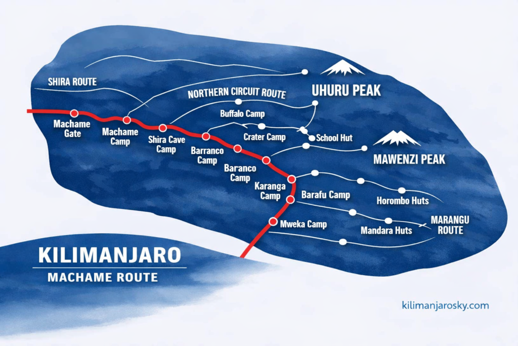
MACHAME route
Machame Route Kilimanjaro | 6–7 Day Guide, Price & Itinerary/
Price
$2450
Age
10-80
Duration
6-7 Days
MACHAME
ROUTE AT A GLANCE
Pricing by route: for New Year and Christmas, the price is $200 more per person.
Duration
6 or 8 days
$2250 for 6 days and $2450 for 7.
Distance
~62km-38.5 miles total (ascent + descent)
Start gate
Machame Gate, 1,800m, (5,906 ft)
Summit
Uhuru Peak, 5,895 m (19,341 ft)
Highest camp
Barafu Camp, 4,673 m (15,331 ft)
Difficulty
Moderate to challenging
Accommodation
Camping throughout
Success rate
High (we recommend 7-day option)
Best season
January–March, June–October
Trail traffic
High — most popular route on the mountain
MACHAME
WHO THIS ROUTE IS FOR
The Machame route suits climbers who want significant terrain variety, a strong acclimatization profile, and don’t mind sharing the trail with other trekkers. It’s a demanding climb — not a walk — but it’s achievable for fit, well-prepared people without prior mountaineering experience.
If this is your first Kilimanjaro and you want 8 days to acclimatize, consider Lemosho instead. If you have prior experience at altitude or specifically want Machame’s terrain, the 7-day option gives you a meaningful acclimatization advantage over the 6-day version.
THE ROUTE: Machame is called the “Whiskey Route” — the harder counterpart to Marangu’s “Coca Cola Route.” That nickname was earned. It’s a serious climb with demanding sections, and the variety of landscape it passes through is part of what makes it the mountain’s most popular trail.
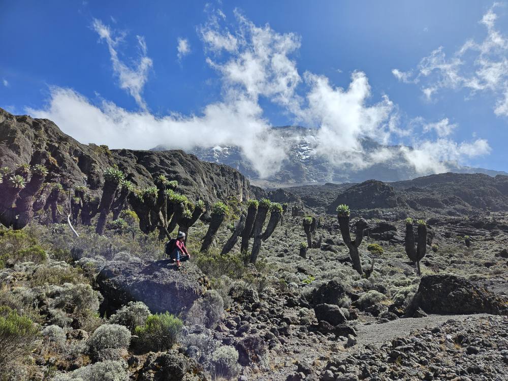
You enter through Machame Gate at 1,800m, move through dense montane rainforest on day one, and progressively climb into heather and moorland, across the vast Shira Plateau, and up toward the volcanic cone. The route uses Kilimanjaro’s most effective acclimatization technique: climb high each day, sleep lower. On day three you push up to Lava Tower at 4,630m before descending to Barranco Camp at 3,960m. That single day does more for your body’s adjustment than almost anything else on the mountain.
Day four involves the Barranco Wall — a near-vertical scramble up a rocky cliff face that sounds more alarming than it is. You’ll use your hands. It takes about two hours. It’s the most memorable section of Machame for most clients, and the views from the top are the kind that stop conversation mid-sentence.
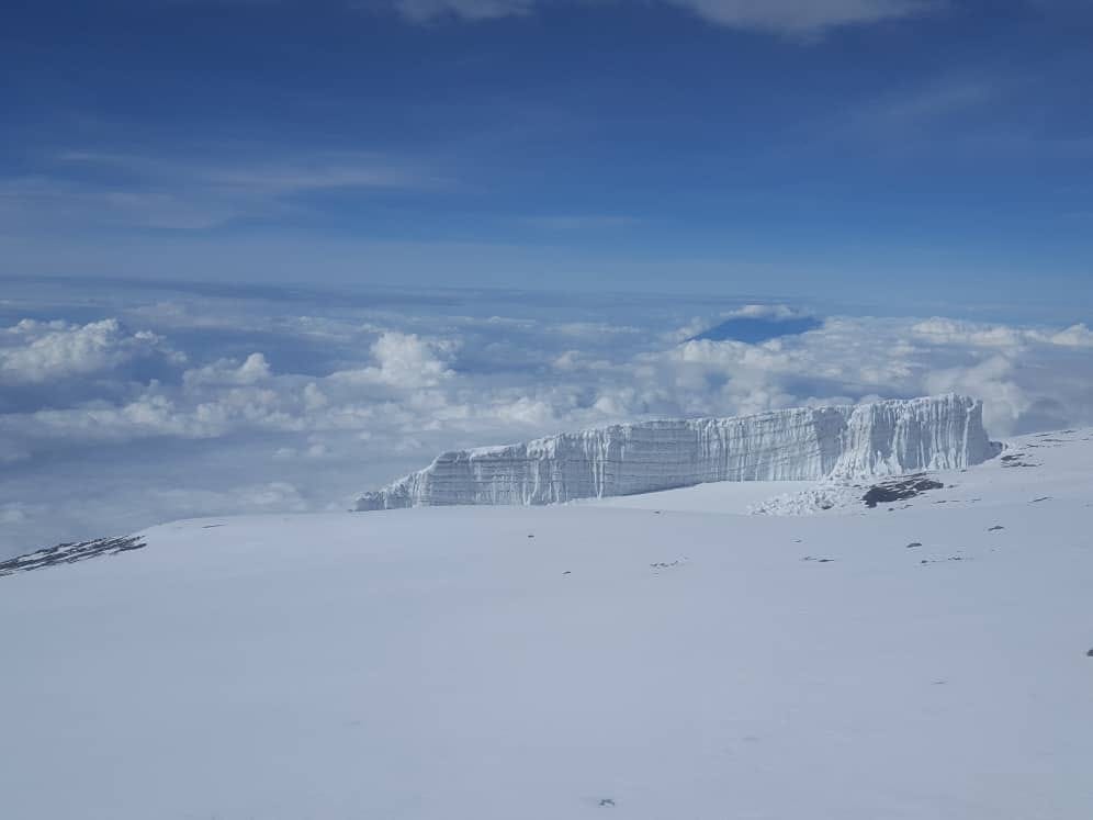
The final push leaves Barafu Camp at midnight or 1am, in the dark, in the cold. You’ll walk slowly — pole pole — for 5–6 hours to reach Stella Point (5,756m) on the crater rim, then continue to Uhuru Peak (5,895m). Descent is the same day, all the way to Mweka Camp at 3,100m, and out through Mweka Gate the following morning.
7-DAY ITINERARY – MACHAME ROUTE KILIMANJARO
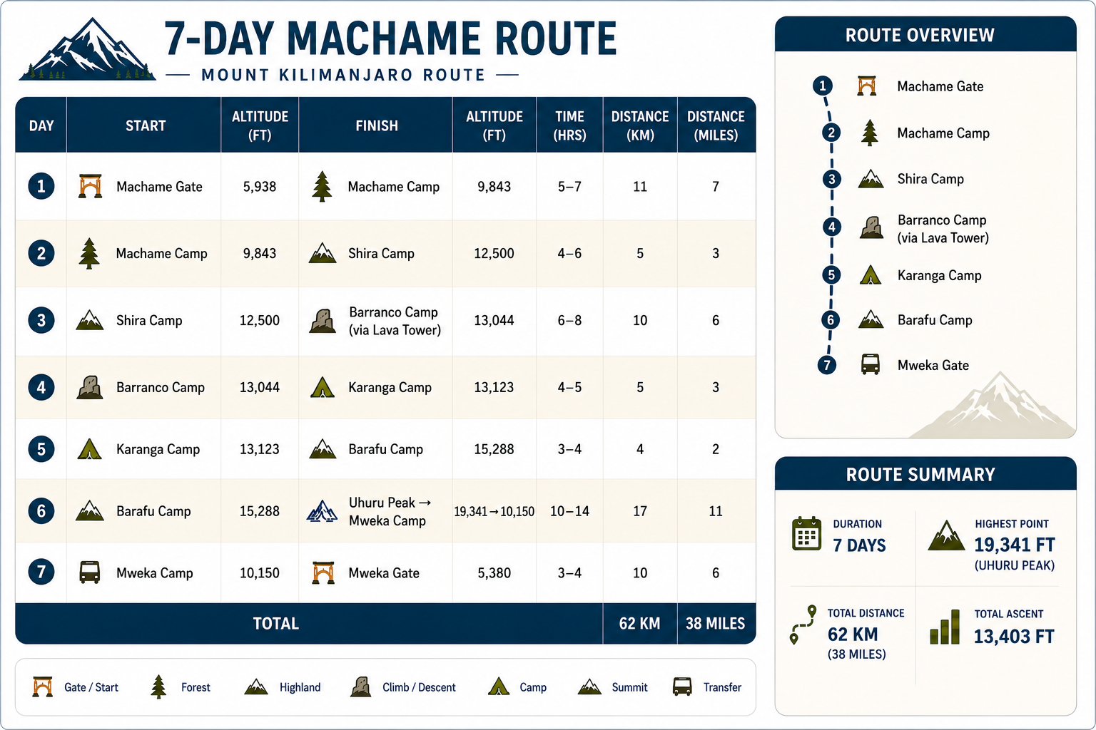
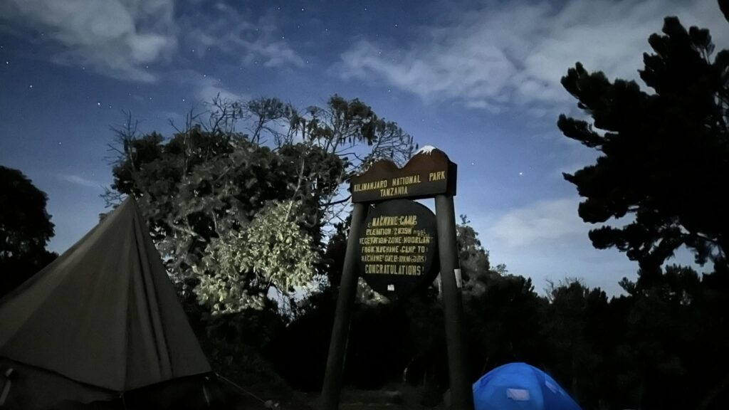
Day 1 — Machame Gate to Machame Camp
Machame Gate (1,800 m / 5,906 ft) → Machame Camp (2,980 m / 9,777 ft) ~5–6 hours hiking | Elevation gain: ~1,180 m / 3,871 ft
You start in farmland and enter the forest within the first hour. The canopy is dense; on a clear morning, shafts of light break through the trees. The trail rises steadily through moss-draped trees, giant ferns, and occasional bursts of colour from Impatiens and Lobelia. By late afternoon you’re at Machame Camp, above the clouds, with your first views of the plains below.
Day 2 — Machame Camp to Shira Camp
Machame Camp (2,980 m / 9,777 ft) → Shira Camp (3,840 m / 12,598 ft)
The forest gives way to heather and moorland. The vegetation thins; the mountain opens up. You’ll cross a ridge and get your first proper views of Kibo — the volcanic cone that holds Uhuru Peak. Shira Camp sits on the edge of the ancient Shira Plateau, one of Kilimanjaro’s three volcanic peaks, now an open, windswept highland.
Day 3 — Shira Camp to Barranco Camp (via Lava Tower)
Shira Camp (3,840 m / 12,598 ft) → Lava Tower (4,630 m / 15,190 ft) → Barranco Camp (3,960 m / 12,992 ft) ~7–8 hours hiking | Net elevation gain: ~120 m / 394 ft (after ascent and descent)
The most important acclimatization day on the route. You climb 790m to Lava Tower — a giant volcanic plug rising from the plateau — eat lunch at altitude, then descend 670m to Barranco Camp. Your body gains altitude and adapts; your sleeping altitude is only marginally higher than last night. This “climb high, sleep low” principle is why Machame’s success rate is high despite being a 6–7 day route.
Day 4 — Barranco Camp to Karanga Camp (via Barranco Wall)
Barranco Camp (3,960 m / 12,992 ft) → Karanga Camp (4,035 m / 13,238 ft) ~4–5 hours hiking | Elevation gain: ~75 m / 246 ft
Barranco Wall first. The scramble is hands-on, sometimes exposed, always memorable. Your guide will be with you through every section. From the top, the path continues across the southern face of the mountain to Karanga Camp. It’s a relatively short day by distance but significant by experience.
Day 5 — Karanga Camp to Barafu Camp
Karanga Camp (4,035 m / 13,238 ft) → Barafu Camp (4,673 m / 15,331 ft) ~4–5 hours hiking | Elevation gain: ~638 m / 2,093 ft
Above Karanga, the vegetation mostly disappears. The landscape becomes volcanic desert — rock, scree, thin air. Barafu (“ice” in Swahili) is your high camp, perched on a rocky ridge with the summit cone looming above. You arrive early afternoon, rest, eat, sleep by 7pm. Your guide wakes you at midnight or 1am.
Day 6 — Summit Day and Descent to Mweka Camp
Barafu Camp (4,673 m / 15,331 ft) → Stella Point (5,756 m / 18,885 ft) → Uhuru Peak (5,895 m / 19,341 ft) → Mweka Camp (3,100 m / 10,171 ft) ~14–16 hours total | Elevation gain to Uhuru: ~1,222 m / 4,010 ft | Descent to Mweka: ~2,795 m / 9,170 ft
You leave in darkness. The headlamp trail stretches above you; your guide sets the pace — slow, deliberate, consistent. The cold is serious at this altitude; temperatures can reach -15°C to -25°C with windchill. You breathe through it. Stella Point on the crater rim arrives first — many people feel relief here; the gradient eases. From Stella to Uhuru Peak is another 45 minutes along the crater rim. The summit sign, the view, the feeling — they’re yours.
Descent to Mweka Camp is the same day. Your legs will feel it.
Day 7 — Mweka Camp to Mweka Gate
Mweka Camp (3,100 m / 10,171 ft) → Mweka Gate (1,640 m / 5,381 ft) ~3–4 hours hiking | Elevation loss: ~1,460 m / 4,790 ft
Through forest, past giant heather. A shorter final walk. Certificates are issued at the gate — Uhuru Peak certificate for those who summited, Stella Point certificate for the crater rim. Transfer back to Moshi.
MACHAME ROUTE ACCLIMATIZATION PROFILE
Machame’s acclimatization profile is one of the strongest on Kilimanjaro, built around two core principles:
- Climb high, sleep low — The Lava Tower detour on Day 3 exposes your body to 4,630 m / 15,190 ft while you sleep at 3,960 m / 12,992 ft. This triggers red blood cell production and improves oxygen processing. Machame builds this in by design.
- Progressive altitude gain — You sleep at:
- 2,980 m / 9,777 ft (Machame Camp)
- 3,840 m / 12,598 ft (Shira Camp)
- 3,960 m / 12,992 ft (Barranco Camp)
- 4,035 m / 13,238 ft (Karanga Camp)
- 4,673 m / 15,331 ft (Barafu Camp)
Each night, your sleeping altitude rises by a manageable amount rather than a dramatic jump.
The 7-day Machame Route adds an extra night at Barranco Camp (3,960 m / 12,992 ft) or Karanga Camp (4,035 m / 13,238 ft), giving your body an additional 24 hours in the 3,960–4,035 m range before the final push. For most climbers, the 7-day option is worth it. The 6-day can make sense for very fit clients, but acclimatization is always stronger with the extra day.
DIFFICULTY & FITNESS and Machame route
Machame is a demanding trekking route. The daily hiking hours range from 4 to 8, with the summit push reaching 14–16 hours on the final day. Barranco Wall requires scrambling and is not suitable for clients with severe vertigo or restricted upper body mobility.
The fitness benchmark we use: if you can run 10km in one hour, three times a week, your aerobic base is in the right range. Machame also requires strong quadriceps for the descent from the summit — the downhill from Barafu to Mweka is long and steep.
No technical climbing skills are required.
BEST TIME TO CLIMB THE MACHAME ROUTE
Machame can be climbed year-round, but two dry seasons offer the best conditions:
January to mid-March: Clear, cold, quieter than peak season. Excellent for summit visibility.
June to October: Peak season. July and August are the busiest months on the mountain. Conditions are reliably good; expect more company on the trail.
April–May and November: Tanzania’s rainy seasons. Wetter, muddier, more cloud cover. The Machame forest section becomes particularly slippery. Possible, but not optimal.
WHAT’S INCLUDED
Every Kilimanjaro Sky Lemosho Route climb includes:
- 1 lead guide + 1 assistant guide per 2 clients
- Quality, waterproof mountain sleeping tents
- Cook and assistant cook
- 3–4 porters per client (20kg maximum, weighed at Londorossi Gate)
- All meals throughout the 8 days — breakfast, lunch, dinner, trail snacks
- Pulse oximeters, supplemental oxygen cylinders, full medical kit
- Camping equipment — tents, sleeping mats, dining tent, cooking equipment
- Emergency oxygen
- Clean drinking water
- TANAPA park fees and rescue levy
- Kilimanjaro Airport transfers
- Accommodation in Moshi on arrival and before departure
- Portable Toilet
- Londorossi Gate 4WD transfer (included)
- Certificate of completion issued at Mweka Gate
Not Included
- Flights
- Alcoholic and soft drinks
- Visa fees
- Travel insurance
HEALTH MONITORING ON MACHAME
Your guide checks your SpO2 (blood oxygen saturation) every morning, every evening, and whenever your pace or energy changes. Two thresholds trigger increased monitoring: readings below 75%, or a drop of more than 5% from a prior reading.
Symptoms of severe altitude illness — confusion, persistent cough, breathlessness at rest — trigger mandatory descent. Your guide has full authority to call this at any point. No pressure from the office. No incentive to push when the signs say stop.
We carry supplemental oxygen on every Machame climb. It is not a guarantee of reaching the summit; it is part of a complete emergency response capability.
CTA: Inquire about Machame Route dates and pricing→ [Contact]
Secondary CTA: Compare all routes → [Routes overview]
MACHAME ROUTE FAQ
Machame Route Frequently asked questions