Rongai ROUTE
6-Day Rongai Route, Price and Itinerary.
Price
$2050
Age
10-80
Duration
6 Days
RONGAI CIRCUIT
RONGAI ROUTE AT A GLANCE
Pricing by route: for New Year and Christmas, the price is $200 more per person.
Duration
6 Days
$2050 for 6 days.
Distance
~65 km (40.4 mi)
Start gate
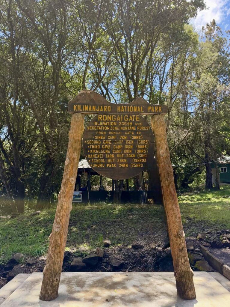
Rongai Gate, 1,950 m (6,398 ft)
(near Kenya border)
Summit
Uhuru Peak, 5,895 m (19,341 ft)
Highest camp
School Hut / Kibo Camp, ~4,750 m
(15,584 ft)
Difficulty
Moderate
Accommodation
Camping throughout
Success rate
Good
Best season
Year-round (best northern approach in wetter months)
Trail traffic
Low to moderate
Quietest of the main routes
Descent
Via Marangu Gate (different trail from ascent)
RONGAI
WHO THIS ROUTE IS FOR
Rongai suits climbers who want a different perspective on the mountain — literally and figuratively. The northern approach puts you on Kilimanjaro’s least-travelled side, moving through landscape that most trekkers never see. The terrain is drier and more open than the lush southern routes; the trail is quieter.
It’s a good option if:
- Your climb falls during Tanzania’s wetter months (April–May, November) — Rongai sits in Kilimanjaro’s northern rain shadow and stays drier than the southern approaches when the rains come
- You’ve done a southern route before and want to experience a different side of the mountain
- You want a less-trafficked trail without committing to the 9–10 days of Northern Circuit
One thing to understand: Rongai is a 6-day route, which means fewer acclimatization days than Lemosho (8 days) or Northern Circuit (9–10 days). For a first-time Kilimanjaro climber focused purely on summit success, Lemosho remains our first recommendation. Rongai is our recommendation when there are good reasons to be on the northern side.
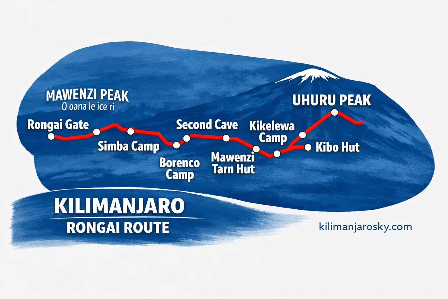
THE ROUTE: RONGAI
Rongai approaches from Tanzania’s northeastern side, close to the Kenyan border. You enter Kilimanjaro National Park at Rongai Gate and climb through savannah and farmland before the ecosystems shift to moorland and then alpine desert. The vegetation is sparser here than on the southern routes — instead of dense forest and giant groundsel, you move through open grassland and heath, with wide views toward Mawenzi Peak and the Kenyan plains below.
The route ascends the northern slopes, passing through Simba Camp, Second Cave, and Third Cave before reaching the high camp (School Hut or Kibo Camp) below the summit cone. Summit night follows — a steep push up the northern face to Gilman’s Point on the crater rim, then on to Uhuru Peak. The descent is via the Marangu trail on the southern side, so you end at Marangu Gate rather than where you started.
The change in descent trail is one of Rongai’s quiet advantages: you experience two distinct sides of the mountain in one climb.
6-DAY ITINERARY – RONGAI Route Kilimanjaro
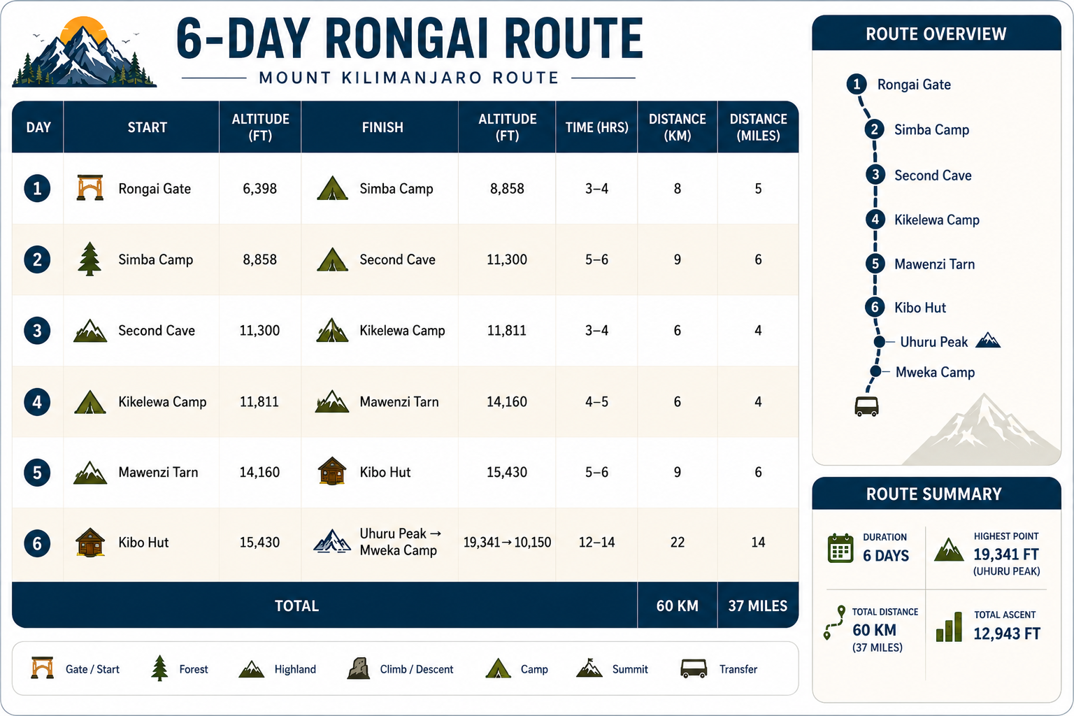
Day 1 — Rongai Gate to Simba Camp
Rongai Gate (1,950 m / 6,398 ft) → Simba Camp (2,625 m / 8,612 ft) | ~4–5 hours hiking | Elevation gain: ~675 m / 2,214 ft
You cross from the park boundary through open land that still shows traces of former agricultural use — the lower Rongai zone was once settled by the Chagga and Maasai communities. Within an hour the vegetation shifts to forest and heather. Simba Camp sits on a ridge with wide eastern views; on a clear first night, the Kenyan plains spread below you. This opening day is both cultural and scenic, easing you into the climb.
Day 2 — Simba Camp to Second Cave Camp
Simba Camp (2,625 m / 8,612 ft) → Second Cave Camp (3,450 m / 11,319 ft) | ~4–5 hours hiking | Elevation gain: ~825 m / 2,707 ft
The trail continues upward through heather and moorland. Giant heather gives way to open grassland. Mawenzi — Kilimanjaro’s jagged secondary peak — comes into clearer view on the right. The “Second Cave” camp takes its name from a small rock overhang nearby. Nights here are extraordinary, with wide skies and brilliant stars.
Day 3 — Second Cave to Third Cave Camp
Second Cave Camp (3,450 m / 11,319 ft) → Third Cave Camp (3,900 m / 12,795 ft) | ~4–5 hours hiking | Elevation gain: ~450 m / 1,476 ft
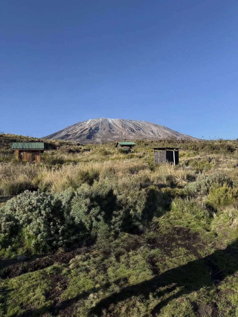
A shorter day, deliberately planned to moderate altitude gain. The terrain becomes rockier as vegetation thins further. Third Cave sits at the edge of the high-altitude zone; the landscape ahead is stark, almost lunar. This is where the mountain’s scale begins to feel immense.
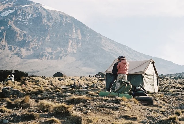
Day 4 — Third Cave to School Hut / Kibo Camp
Third Cave Camp (3,900 m / 12,795 ft) → School Hut (4,750 m / 15,584 ft) | ~4–5 hours hiking | Elevation gain: ~850 m / 2,789 ft
The final camp before summit. The route crosses the saddle on Kilimanjaro’s northern side — open, exposed, with winds sweeping across from the Kenyan plains. School Hut is simple but strategically placed for the northern summit approach. You arrive early afternoon, with time to rest, eat, and sleep by 7 pm.
Day 5 — Summit Day and Descent to Horombo Hut
School Hut (4,750 m / 15,584 ft) → Gilman’s Point (5,681 m / 18,638 ft) → Uhuru Peak (5,895 m / 19,341 ft) → Horombo Hut (3,720 m / 12,205 ft) | ~14–16 hours total
Midnight or 1 am departure up the northern face. The gradient is steep from School Hut, making this one of the harder final approaches. Gilman’s Point at 5,681 m / 18,638 ft is a recognized summit in its own right, perched on the crater rim. Uhuru Peak lies 45 minutes further along the rim — the true roof of Africa.
Descent is via the Marangu trail — south and east, through Kibo Hut and down to Horombo Hut. By afternoon you are in a completely different landscape than where you began the day.
Day 6 — Horombo Hut to Marangu Gate
Horombo Hut (3,720 m / 12,205 ft) → Mandara Hut (2,720 m / 8,924 ft) → Marangu Gate (1,860 m / 6,102 ft) | ~5–6 hours hiking
The Marangu descent passes through moorland and forest, a gentle close to the expedition. At Marangu Gate, certificates are awarded — a formal recognition of your achievement. Transfer back to Moshi follows, with time to celebrate and reflect.
RONGAI IN THE WET SEASON
Kilimanjaro’s main rainfall comes from the south and east — the Indian Ocean moisture systems that drive Tanzania’s April–May and November rains. Rongai’s northern approach sits partially sheltered from these systems.
In practical terms: when the Machame and Lemosho trails are running with water and the forest sections are slippery and cloud-covered, Rongai’s northern side is often clearer and drier. This isn’t guaranteed — the mountain does what it wants — but the pattern is consistent enough to make Rongai our recommendation when clients are committed to climbing in the wetter windows.
ACCLIMATIZATION PROFILE ON RONGAI
Rongai’s acclimatization profile is steady and measured, making it one of the stronger six‑day options. The first night is spent at Simba Camp (2,625 m / 8,612 ft), followed by Second Cave (3,450 m / 11,319 ft) and Third Cave (3,900 m / 12,795 ft). This gradual rise avoids dramatic single‑day jumps, giving your body time to adjust. By Night 4, you reach School Hut (4,750 m / 15,584 ft), the final staging point before summit night. The push to Uhuru Peak (5,895 m / 19,341 ft) is demanding, but the descent to Horombo Hut (3,720 m / 12,205 ft) provides recovery at a lower altitude.
Unlike Machame or Lemosho, Rongai does not include the “climb high, sleep low” detour via Lava Tower. Acclimatization here is achieved through consistent daily progression rather than altitude variation. This makes it less dynamic but still effective, especially compared to Marangu, which compresses acclimatization into fewer days.
Overall, Rongai offers a solid acclimatization structure for a six‑day climb: gradual gains, no extreme jumps, and a balance between exposure and recovery. It doesn’t match the extended profiles of Lemosho (8 days) or the Northern Circuit (9–10 days), but it stands alongside Machame as a reliable mid‑length route — and clearly stronger than Marangu in terms of altitude adaptation.
WHAT’S INCLUDED
Every Kilimanjaro Sky Route climb includes:
- 1 lead guide + 1 assistant guide per 2 clients
- Quality, waterproof mountain sleeping tents
- Cook and assistant cook
- 3–4 porters per client (20kg maximum, weighed at Londorossi Gate)
- All meals throughout the 7 days — breakfast, lunch, dinner, trail snacks
- Pulse oximeters, supplemental oxygen cylinders, full medical kit
- Camping equipment — tents, sleeping mats, dining tent, cooking equipment
- Emergency oxygen
- Clean drinking water
- TANAPA park fees and rescue levy
- Kilimanjaro Airport transfers
- Accommodation in Moshi on arrival and before departure
- Portable Toilet
- Londorossi Gate 4WD transfer (included)
- Certificate of completion
Not Included
- Flights
- Alcoholic and soft drinks
- Visa fees
- Travel insurance
CTA: Inquire about Rongai route dates and pricing→ [Contact]
CTA2: Compare all routes → [Routes overview]
SHIRA ROUTE FAQ
Shira Route Frequently asked questions